Tag:

Winter Storm Warning

Four Inches Of Snow Forecasted Along Jersey Shore Overnight Four Inches Of Snow Forecasted Along Jersey Shore Overnight
Four Inches Of Snow Forecasted Along Jersey Shore Overnight Many parts of the Jersey Shore avoided the snow during a pre-Valentine's Day winter storm, but the coast doesn't appear to be dodging it this time. The National Weather Service said the Jersey Shore could see two to four inches of snow overnight and in the morning on Saturday, Feb. 17. All counties in South Jersey are under a winter weather advisory for the duration of the storm, with some winter storm warnings expected. The snow is expected to begin across South Jersey at around 1 a.m., according to the NWS. Places along the Pennsylvania border could see the snow start falling a little ear…
Winter Storm Warning In Effect For Lower Bucks County Winter Storm Warning In Effect For Lower Bucks County
Winter Storm Warning In Effect For Lower Bucks County Officials are advising residents across southeastern and central Pennsylvania to take caution ahead of the snowstorm predicted for Friday, Jan. 19, according to National Weather Service meteorologists.  Chester, Delaware, Philadelphia, and parts of lower Bucks and Montgomery counties are under a winter storm warning as of 5 p.m. Thursday. In Adams, Berks, Cumberland, Dauphin, Lancaster, Lebanon, Lehigh, Northampton, and upper Bucks and Montgomery counties, a winter weather advisory is in place.  NWS's Mount Holly, New Jersey station says snow will begin to fall around 4 to 7 a.m. …
Latest Forecast Calls For Up To 18 Inches Of Snow In Parts Of NJ As Noreaster Nears Latest Forecast Calls For Up To 18 Inches Of Snow In Parts Of NJ As Noreaster Nears
Latest Forecast Calls For Up To 18 Inches Of Snow In Parts Of NJ As Noreaster Nears A powerful Noreaster headed to the region will slam some parts of New Jersey with up to 18 inches of snow, while the rest of the state will see rain and gusty winds, forecasters say. ALSO SEE: These NJ Schools Are Closed, Delayed Tuesday, March 14 Drizzly weather will change to snow late Monday night across Bergen, Morris, Passaic, Warren and Sussex Counties. Accuweather storm prediction.AccuWeather Sussex County is expected to get the most amount of snow: Between 12 and 18 inches, according to the NWS. Snow will change to a wintry mix around 1 p.m. on Tuesday, March 14. Precipitation …
Projected Snowfall Totals Increase For Major Winter Storm Headed To Region Projected Snowfall Totals Increase For Major Winter Storm Headed To Region
Projected Snowfall Totals Increase For Major Winter Storm Headed To Region Projected snowfall totals have increased for a major winter storm headed to the Northeast. The complex system will bring the first widespread plowable snowfall of the season and cause hazardous travel conditions at times Monday night, Feb. 27 into Tuesday morning, Feb. 28, according to the National Weather Service. A widespread 6 to 8 inches is now expected in interior portions of New York and Connecticut, where wet and heavy snow is expected. (Areas shown in yellow in the first image above from the National Weather Service.) Up to 4 to 6 inches is now possible for parts of the n…
Nor'easter: State Of Emergency Issued For These NY Counties Nor'easter: State Of Emergency Issued For These NY Counties
Nor'easter: State Of Emergency Issued For These NY Counties A State of Emergency has been declared by Gov. Kathy Hochul for parts of New York as the first nor’easter of 2022 rapidly approaches. Gov. Kathy Hochul announced that parts of downstate New York that are expected to get hit the hardest have been placed under the state of emergency as upwards of 16 inches of snow are expected in some parts of the state. Related story - Nor'easter Nears: Track Shifts For Blockbuster Storm With Projected Snowfall Totals Increasing The State of Emergency, which is effective as of 8 p.m. on Friday, Jan. 28 was declared for these counties in New York: Suffolk…
BLIZZARD: Foot Of Snow Possible Across South Jersey BLIZZARD: Foot Of Snow Possible Across South Jersey
Blizzard: Foot Of Snow Possible Across South Jersey 
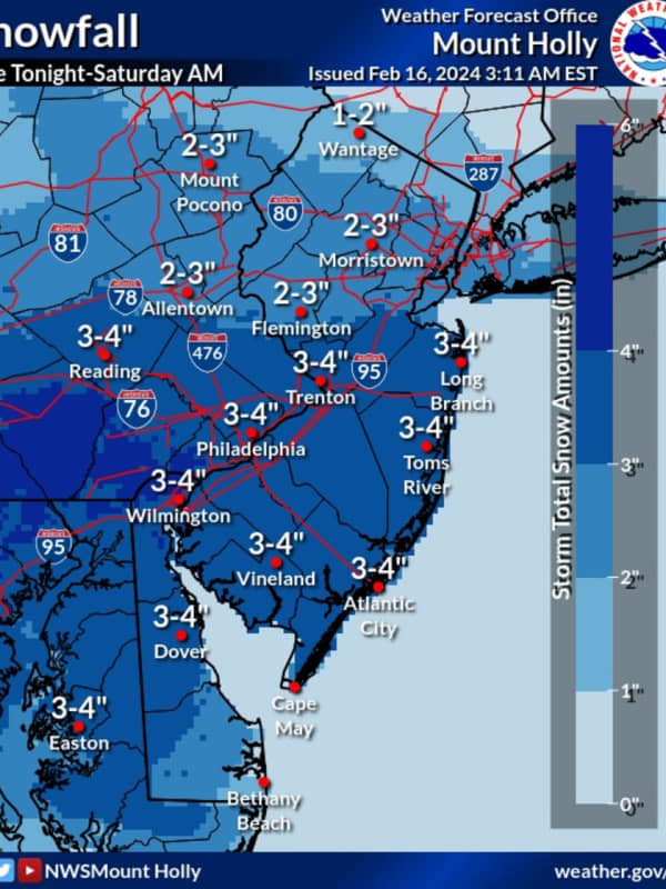
Up to a foot of snow was possible Monday in South Jersey, with blizzard conditions likely to last until the afternoon. Only a light dusting to an inch was expected in the northern part of the state. A State of Emergency was declared in Atlantic, Burlington, Cape May, Cumberland and Ocean counties by Gov. Phil Murphy Sunday night. Meanwhile, the National Weather Service expanded a winter storm warning to Atlantic, southeast Burlington, Camden, Cape May, Cumberland, Gloucester, Ocean and Salem counties until 4 p.m., according to the National Weather Service.  Snowfall rates around…
Eye Of The Storm: Nor'easter Brings Heavy Snow, Dangerous Winds That Could Cause Power Outages Eye Of The Storm: Nor'easter Brings Heavy Snow, Dangerous Winds That Could Cause Power Outages
Eye Of The Storm: Nor'easter Brings Heavy Snow, Dangerous Winds That Could Cause Power Outages A major Nor'easter has arrived in the region, ushering the start of February with heavy snow, blizzard-like conditions, and dangerous winds that could cause power outages. Most of the region will see 12 to 18 inches of snow with locally higher amounts of 18 to 24 hours in some parts of the New York metro area and throughout New England. For the latest snowfall projections, see the first image above. The brunt of one of the biggest storms in years will be during the day on Monday, Feb. 1 with snow falling at rates of 1 to 2 inches an hour of snow or even higher rates at times with wind gust…
Local Overnight Snowfall Totals, Current Conditions For Thursday, Dec. 17 Local Overnight Snowfall Totals, Current Conditions For Thursday, Dec. 17
Local Overnight Snowfall Totals, Current Conditions For Thursday, Dec. 17 Overnight the winter storm dropped between 7 and 12 inches of snow on Western Massachusetts and Northern Connecticut. As snow continues to fall, the National Weather Service provided overnight snowfall totals. At 7 a.m. here is how much snow had fallen in your area - Hartford, Hampden, Hampshire, and Worcester counties: Hartford County Simsbury - 11 inches Bradley Airport - 10.9 inches Canton - 10.5 inches Manchester - 10 inches Hampden County Longmeadow - 12 inches Southwick - 10.3 inches Westfield - 9.3 inches East Longmeadow - 8.5 inches Monson - 8 inches Chicopee -7.5 inches Hampshi…
Update: Schools Announce Cancelations, Remote Learning For Thursday, Dec. 17 Update: Schools Announce Cancelations, Remote Learning For Thursday, Dec. 17
Update: Schools Announce Cancelations, Remote Learning For Thursday, Dec. 17 With people expecting to see more than 1 foot of snow on the ground Thursday, Dec. 17, Connecticut schools are arranging to have the students attend school remotely or call for a snow day. A Winter Storm Warning has been put into effect for all of Connecticut from Wednesday, Dec. 16, 2 p.m. to Thursday, Dec. 17, 1 p.m., according to the National Weather Service.  Schools and districts that have made decisions about attendance on Thursday include: Avon School District - Closed Bethany School District - Closed Bolton School District- Closed Bozrah School District - Closed Canton …
Storm: Snowfall Could Add  Up To 20 Inches In Parts Of Central Mass Storm: Snowfall Could Add  Up To 20 Inches In Parts Of Central Mass
Storm: Snowfall Could Add Up To 20 Inches In Parts Of Central Mass Meteorologists have increased the total snowfall forecast as a slow-moving storm is expected to reach Central Massachusetts this evening, Wednesday, Dec. 16. The National Weather Service says areas of Central and Western Massachusetts, as well as the Berkshires, may see up to 20 inches of snow accumulation in some places. Temperatures will be in the low to mid-20s. A Winter Storm Warning has been put into effect from Wednesday, Dec. 16, 7 p.m. to Thursday, Dec. 17, 1 p.m. In the Northern part of Worcester County, the forecast is for winds blowing at 15-20 mph with gusts of up to 30 mph aft…
Storm: Snowfall Could Add Up To 20 Inches In Parts of Western Mass Storm: Snowfall Could Add Up To 20 Inches In Parts of Western Mass
Storm: Snowfall Could Add Up To 20 Inches In Parts of Western Mass A snowstorm that promises to blanket much of Massachusetts and Connecticut with more than a foot of snow in some regions, is set to begin Wednesday, Dec. 16, evening. Meteorologists have raised their predictions of total snowfall for the area since Tuesday, Dec. 15. The National Weather Service says areas of Western and Central Massachusetts, as well as the Berkshires, may see up to 20 inches of snow accumulation. Meanwhile, communities in Eastern Hampden and Hampshire counties can expect 8-12 inches of snow to fall overnight, according to the National Weather Service, with 12-16 inch…
Latest Snowfall Predictions, Timing Of Powerful Winter Storm Headed To NJ, PA This Afternoon Latest Snowfall Predictions, Timing Of Powerful Winter Storm Headed To NJ, PA This Afternoon
Latest Snowfall Predictions, Timing Of Powerful Winter Storm Headed To NJ, PA This Afternoon New Jersey and Pennsylvania are expected to see the first winter storm Wednesday afternoon into Thursday morning. Precipitation will begin early Wednesday afternoon in South Jersey, then head north to Central Jersey and Philadelphia, where 6 to 12 inches of snow are predicted, the National Weather Service says. Strong winds and heavy sleet were likely across South Jersey and Philadelphia, with a chance of rain leading along the Jersey Shore. Coastal flooding was possible, especially late Wednesday night and early Thursday morning, meteorologists say. Snowfall is expected to begin in N…
Brand-New Snowfall Projections Released For Powerful Nor'easter With Updated Timing For Storm Brand-New Snowfall Projections Released For Powerful Nor'easter With Updated Timing For Storm
Brand-New Snowfall Projections Released For Powerful Nor'easter With Updated Timing For Storm One of the most potent snowstorms in several years is set to slam the area with the brand-new models calling for a foot or more of accumulation for most of the region and wind gusts of up to 45 miles per hour that could cause power outages. A Winter Storm Warning is now in effect from 2 p.m. Wednesday, Dec. 16 through 1 p.m. Thursday, Dec. 17.  Travel could be very difficult to impossible during much of that time frame, the National Weather Service said in a Hazardous Weather Outlook statement on the powerful Nor'easter issued early Tuesday, Dec. 15. Generally, total snow ac…
Eye Of The Storm: Here Are Brand-New Snowfall, Rainfall Projections Eye Of The Storm: Here Are Brand-New Snowfall, Rainfall Projections
Eye Of The Storm: Here Are Brand-New Snowfall, Rainfall Projections A storm system bringing accumulating snow to inland areas and rain at times to the entire region has arrived. Precipitation arrived as light, wet snow north of I-287 and the Merritt Parkway and as rain farther south just before daybreak on Monday, March 23. After a lull later in the morning, precipitation will return around 2 p.m. As the temperature will be above freezing south of I-84, it will be rain. For snowfall and rainfall projections, see the first and second images above. But north of I-84, anywhere from 2 to 6 inches is expected with locally higher amounts. (See third image above…
Storm Watch: Here's When Snowfall Will Arrive, End In Round 2 Of Storm Storm Watch: Here's When Snowfall Will Arrive, End In Round 2 Of Storm
Storm Watch: Here's When Snowfall Will Arrive, End In Round 2 Of Storm Powered by a strong band of snow, a round of moderate to heavy snowfall will arrive in the afternoon and continue through the evening in areas farther inland on Monday, Dec. 2. There have been reports just past noontime of snowfall moving west to east, but not sticking to surfaces where the temperature is above freezing. Nearly the entire region should see snowfall at times between 3 p.m. and 6 p.m. with generally about 1 to 2 inches of accumulation expected during that time frame. Most of the snow will fall after dark and in areas north and west. As for the latest expected snowfall …
Storm Alert: Here's How Much Snowfall To Expect In Round 2 Of Nor'easter Storm Alert: Here's How Much Snowfall To Expect In Round 2 Of Nor'easter
Storm Alert: Here's How Much Snowfall To Expect In Round 2 Of Nor'easter Get set for Round Two. Powered by a heavy band of snow, another round of moderate to heavy snowfall is expected later in the afternoon into the evening on Monday, Dec. 2. Most of the snow will fall after dark. Areas south of I-287 and the Merritt Parkway, including New York City, will see between 3 and 4 inches of accumulation. Accumulation amounts will be a bit lower on Long Island, with 2 to 3 inches expected in Nassau County and 1 to 2 inches in Suffolk County. Further inland, expect 4 to 6 inches of accumulation, with 6 to 8 inches possible in parts of Northern Westchester, Putnam, Ro…
Storm Track: Here's Latest On Slow-Moving Nor'easter Bringing Snow, Ice, Rain To Region Storm Track: Here's Latest On Slow-Moving Nor'easter Bringing Snow, Ice, Rain To Region
Storm Track: Here's Latest On Slow-Moving Nor'easter Bringing Snow, Ice, Rain To Region A two-part storm system is bringing a mix of snow, rain and ice just as millions return home from Thanksgiving and then head back to work.Areas farthest north and inland will see the most snow -- with up to a foot of accumulation possible in Dutchess and Ulster counties in the Hudson Valley and Litchfield County in Connecticut -- but there will be treacherous travel conditions at times throughout the region, even Long Island, where parts of central Nassau County could get 2 to 3 inches of snowfall. For the latest snowfall projections, check the first two images above. For expected ice and ra…
Storm Track: Here's Latest On Slow-Moving Nor'easter Bringing Snow, Ice, Rain To Region Storm Track: Here's Latest On Slow-Moving Nor'easter Bringing Snow, Ice, Rain To Region
Storm Track: Here's Latest On Slow-Moving Nor'easter Bringing Snow, Ice, Rain To Region Click here for a related story: Schools Announce Closures Due To Storm A two-part storm system is bringing a mix of snow, rain and ice just as millions return home from Thanksgiving and then head back to work. Areas farthest north and inland will see the most snow -- with up to a foot of accumulation possible in Dutchess and Ulster counties in the Hudson Valley and Litchfield County in Connecticut -- but there will be treacherous travel conditions at times throughout the region, even Long Island, where parts of central Nassau County could get 2 to 3 inches of snowfall. For the latest …
Storm Track: Here's Latest On Slow-Moving Nor'easter Bringing Snow, Ice, Rain To Region Storm Track: Here's Latest On Slow-Moving Nor'easter Bringing Snow, Ice, Rain To Region
Storm Track: Here's Latest On Slow-Moving Nor'easter Bringing Snow, Ice, Rain To Region A two-part storm system is bringing a mix of snow, rain and ice just as millions return home from Thanksgiving and then head back to work. Areas farthest north and inland will see the most snow -- with up to a foot of accumulation possible in Dutchess and Ulster counties in the Hudson Valley and Litchfield County in Connecticut -- but there will be treacherous travel conditions at times throughout the region, even Long Island, where parts of central Nassau County could get 2 to 3 inches of snowfall. For the latest snowfall projections, check the first two images above. For expected ice and …
Storm Track: Here's Latest On Slow-Moving Nor'easter Bringing Snow, Ice, Rain To Region Storm Track: Here's Latest On Slow-Moving Nor'easter Bringing Snow, Ice, Rain To Region
Storm Track: Here's Latest On Slow-Moving Nor'easter Bringing Snow, Ice, Rain To Region Click here for a related story: Schools Announce Closures For Monday, Dec. 2 A two-part storm system is bringing a mix of snow, rain and ice just as millions return home from Thanksgiving and then head back to work. Areas farthest north and inland will see the most snow -- with up to a foot of accumulation possible in Dutchess and Ulster counties in the Hudson Valley and Litchfield County in Connecticut -- but there will be treacherous travel conditions at times throughout the region. For the latest snowfall projections, check the first, second and third images above.  Winter Storm W…
Deep Freeze Will Follow Storm Bringing Rain, Icy, Slippery Wintry Mix, Snow Farther North Deep Freeze Will Follow Storm Bringing Rain, Icy, Slippery Wintry Mix, Snow Farther North
Deep Freeze Will Follow Storm Bringing Rain, Icy, Slippery Wintry Mix, Snow Farther North The complex storm system that is bringing more freezing rain and rain than snow to the area will bring a big change in the weather pattern. Areas north of I-287 and the Merritt Parkway are seeing an icy and slippery wintry mix on Sunday morning, Jan. 20. Significant snowfall totals of up to a foot are expected north of I-84. A Winter Storm Warning remains in effect until 6 p.m. Sunday for areas north of I-287 and the Merritt Parkway. (Shown in pink in the third image above.) A Winter Weather Advisory covers Southern Westchester and coastal Fairfield County. Precipitation will continue into…
Crash Shuts Down Merritt Parkway Stretch Crash Shuts Down Merritt Parkway Stretch
Crash Shuts Down Merritt Parkway Stretch This story has been updated with new incidents. With snow overspreading the area, a crash has caused the closure of a stretch of the Merritt Parkway late Thursday afternoon. The crash, reported around 5:30 p.m., is northbound, closing the lanes between Route 137/High Ridge Road (Exit 35) in Stamford and Route 106/Exit 36 in New Canaan. There is gridlock on the northbound side of I-95 with two disabled vehicles. One is blocking the center lane between Noroton Avenue (Exit 10) and Route 1 (Exit 11) at 6 p.m. and the other the right lane between Atlantic Street (Exit 8) an…
Numerous Crashes, Stuck Vehicles Reported Throughout Area Numerous Crashes, Stuck Vehicles Reported Throughout Area
Numerous Crashes, Stuck Vehicles Reported Throughout Area This story has been updated with new incidents. A wintry mix of snow and sleet has overspread the area, marking the arrival of a rare pre-Thanksgiving winter storm, and numerous crashes had already been reported as of 4:30 p.m. Thursday. Throughout the evening, vehicles have been reported stuck on numerous roadways with local police agencies warning motorists of the hazardous conditions. Many side streets quickly became impassable. Here's a rundown of incidents reported starting late afternoon through the evening commute. Westchester County Eastbound I-287 in Westchester, crash blocking…
Dutchess Emergency Operations Center Activated For Storm Dutchess Emergency Operations Center Activated For Storm
Dutchess Emergency Operations Center Activated For Storm With a significant amount of snow still possible in Dutchess County on Wednesday, officials have activated the Dutchess County Emergency Operations Center with local, county and state experts monitoring the incoming storm. Dutchess County remains under a Winter Storm Warning, which will be in effect until 8 a.m. on Thursday morning. According to the National Weather Service, snow accumulations may be between 3 and 7 inches in central and northern Dutchess, with 6 to 10 inches expected in the southern parts of the county. Although the snow isn’t expected to hit the area until later in the af…
Latest Projected Snowfall Totals For Fourth Nor'easter Latest Projected Snowfall Totals For Fourth Nor'easter
Latest Projected Snowfall Totals For Fourth Nor'easter The first full day of spring will bring as much as a foot or more of snow to the tristate area as the fourth Nor'easter of the month moves through the region on Wednesday. The latest snowfall projections, by the National Weather Service and AccuWeather.com, can be viewed in the first two images above. Snow is expected to begin sometime Wednesday morning and continue throughout the day, becoming heavy at times Wednesday afternoon and evening with snowfall rates of 1 to 3 inches per hour are possible for the afternoon and evening, said the National Weather Service. Visibility will be one-quar…
Stamford Declares Snow Emergency Stamford Declares Snow Emergency
Stamford Declares Snow Emergency Projected Snowfall Totals Increase As Fourth Nor'easter Nears Stamford Mayor David Martin been March's fourth Nor'easter in a month to the punch late Tuesday by declaring a snow emergency, effective at 11 p.m. March 20. The tristate area is now to receive as much as a foot of snow on Wednesday, as reported here by Daily Voice. Stamford's Snow Emergency requires the removal of all vehicles on designated snow emergency streets. City parking garages will be open and free of charge until at least Thursday at noon. (See locations below.). “Light snow is now forecast to spread slowly into the st…
Projected Snowfall Totals Increase As Fourth Nor'easter Nears Projected Snowfall Totals Increase As Fourth Nor'easter Nears
Projected Snowfall Totals Increase As Fourth Nor'easter Nears Following what was a relentless winter, in a cruel twist, the first full day of spring will bring as much as a foot or more of snow to the tristate area as the fourth Nor'easter of the month moves through the region on Wednesday. The latest snowfall projections, issued late Tuesday afternoon by the National Weather Service, can be viewed in the first image above. Snow is expected to begin sometime Wednesday morning and continue throughout the day, becoming heavy at times Wednesday afternoon and evening with snowfall rates of 1 to 3 inches per hour are possible for the afternoon and evening,…
Projected Snowfall Totals Increase For Midweek Nor'easter Projected Snowfall Totals Increase For Midweek Nor'easter
Projected Snowfall Totals Increase For Midweek Nor'easter New Nor'easter's Heavy Snow, Strong Winds Could Cause Power Outages A day after spring has sprung, parts of the tristate area may be buried in close to a foot of snow by the fourth Nor'easter of the month, according to the latest forecast by the National Weather Service. The new projections now call for 6 to 8 inches of accumulation for Wednesday's storm for most of the region, with higher amounts toward the coast. (See first image above.) Winter Storm Warnings and Watches have now been issued for the most of the area. Precipitation is expected to arrive in the form of a mix of sleet and …
Numerous Crashes, Spinouts During Snowy Morning In Connecticut Numerous Crashes, Spinouts During Snowy Morning In Connecticut
Numerous Crashes, Spinouts During Snowy Morning In Connecticut The latest batch of winter weather has left roadways treacherous for drivers, as Connecticut State Police troopers continue making the rounds, responding to multiple crashes and spin-outs, most of which occurred during the morning commute. Connecticut State Police troopers were all over the place on Tuesday morning, responding to 27 crashes with minor or no injuries, and assisting 64 spin-outs and motorists who got stuck, including a motorist on I-91 near Wallingford whose car slid off the roadway and into a ditch. Snowfall accumulations in the tristate area will range from 3 to 8 inches. …
Storm Update: Nor'easter's Heaviest Snow Winds Down Storm Update: Nor'easter's Heaviest Snow Winds Down
Storm Update: Nor'easter's Heaviest Snow Winds Down The third Nor'easter to hit the area in a 10-day span arrived overnight and picked up in intensity through the morning commute with bands of heavy snow that quickly created travel difficulties. Snowfall at rates of an inch or more an hour will continue to be possible through late morning. Snowfall accumulations in the tristate area will range from 3 to 8 inches. (See latest projections from the National Weather Service in the image above.) The heaviest snow is expected to wrap up by noontime Tuesday. A Winter Storm Warning is in effect for Fairfield County until 6 p.m. Tuesday. A Winter We…