Find Your Daily Voice
Tags
Follow
News
Schools
Business
Obituaries
Police & Fire
Weather
Neighbors
Lifestyle
Politics
Sports
Events
Traffic
Legal
Real Estate
Tags
Jobs
Shop
Support Us
Follow
Find Your Daily Voice
News
Schools
Business
Obituaries
Police & Fire
Weather
Neighbors
Lifestyle
Politics
Sports
Events
Traffic
Legal
Real Estate
Tags
Jobs
Shop
Support Us
Home
About us
All sites
Advertise with us
Contact us
Terms of use
Privacy policy
Code of ethics
Site Map
© 2024 Cantata Media
Tag:
Wind Chill
Hackensack
Weather
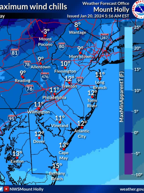
Blowing Snow, Frigid Temps Make For Arctic-Like Weekend: Here's What's In Store For Next Week
Gusty winds and temps in the single digits will make for an arctic-like start to the weekend across New Jersey and parts of Pennsylvania. Saturday, Jan. 20 will be partly sunny with wind chill values between 10 and 15 degrees, and temps reaching a high of between 20 and 25 degrees, the National Weather Service says. Winds will make temps feel like they're in the single digits, and will keep snow blowing through the air until Sunday, Jan. 21, the NWS said. Sunday will reach highs of between 25 and 30 degrees, with winds up to 15 mph. Monday, Jan. 22 will be mostly sunny and slightly more m…
Worcester
Weather
After Record Cold, Expect Warmer-Than-Normal Temps Across Massachusetts: NWS
One of the coldest nights on record will soon give way to warmer-than-usual temperatures on Sunday, Feb. 5, meteorologists said. Massachusetts — and most of New England — suffered arctic conditions Friday night and Saturday as thermometers fell below zero in several parts of the state because of the polar vortex, the National Weather Service said. Boston and Worcester broke records more than 100 years old with minus 8 and minus 10 degrees, respectively. But that's almost balmy compared to the minus 40 degrees it felt in some parts of the state with the wind chill. 🥶 Record cold was ac…
White Plains
Weather
Dangerously Cold Wind Chills Will Be Followed By Big Change In Weather Pattern
Dangerously cold wind chill temperatures will continue to impact the region throughout the day on Saturday, Feb. 4 before there's a big turnaround in temperatures. Wind-chill values of as low as 25 below zero have been reported early Saturday morning. "The cold wind chills could cause frostbite on exposed skin in as little as 30 minutes," the National Weather Service said. After mid-morning, the temperature will gradually begin to climb, reaching a high of around 20 degrees in most spots on Saturday, but wind chill values will be in the teens and single digits. Winds will n…
Suffolk MA
Schools
School Closings: List Grows As Subzero Temperatures Approach Massachusetts
As dangerous wind chills and subzero temperatures are expected to move through the state, many Massachusetts school districts are closing for the day on Friday, Feb. 3. The National Weather Service predicts the lowest wind chills could be between -15 and -45 degrees Fahrenheit from Friday night into Saturday morning. Isolated power outages and snow squalls are expected and the risk for frostbite will also be high. Dangerous Wind Chills Fri-Sat across southern New England. Isolated power outages possible due to strong winds. A few isolated snow squalls possible late tonight into early …
Nassau
Weather
After The Storm: Bitter Cold For Christmas Eve, Xmas Day Before Big Change In Weather Pattern
Let's hope Santa Claus is wearing an extra pair -- or two -- of long johns. That's because Christmas Eve and Christmas Day will be the coldest in decades. A powerful, massive storm that brought a mix of heavy rain, damaging winds, sleet, and snow, has now moved off the coast, but the passage of a cold front accompanying the system has led to a dramatic dip in temperatures. The wind-chill factor on Christmas Eve on Saturday morning, Dec. 24 is below zero degrees in most of the region. After a sunny start, clouds will increase during the day, but the high temperature will only be in the mid…
White Plains
Weather
Band Of Snow Sweeps Through Region, Causing Slippery Roads, Some Delayed School Starts
A band of snowfall moving from north to south is causing slippery roads during the morning commute on Monday, March 28, leading some schools to delay starting times. For a look at areas affected by the band, including parts of the eastern Hudson Valley, central Connecticut and eastern Long Island, check the radar image above. Wind-chill values throughout the region are bone-chilling as a blast of Artic air has arrived. "Conditions over the next few days will be reminiscent of mid-January," said AccuWeather Meteorologist Randy Adkins. Monday will be mostly sunny and blustery, with a high a…
White Plains
Weather
Arctic Blast Will Bring Temperature Drop, Biting Winds With Snow In Parts Of Region
The arrival of Arctic air will make the second half of the final weekend of March feel more like it's the middle of winter than the start of spring, with accumulating snow expected in parts of the Northeast. "Conditions over the next few days will be reminiscent of mid-January," said AccuWeather Meteorologist Randy Adkins. Sunday, March 27 will be partly sunny and blustery with a high temperature in the low 40s. Scattered afternoon showers are possible, with areas farthest north and inland seeing a wintry mix and light snow. See the first image above for areas where accumulating snow…
White Plains
Weather
Here's Next Window For Snowfall As Alberta Clippers Sweep Through Northeast
There are no major winter storms currently on track in the coming days for the region, but quick-hitting snowstorms known as Alberta clippers are forecast for parts of the Northeast, according to AccuWeather.com. Most of the Clipper activity this week will be in upstate New York and northern New England, but there will be a window in which some snow is possible in this region later in the week. Tuesday, Feb. 8 will be partly cloudy with a high temperature in the low 40s, according to the National Weather Service. There will be sunny skies on Wednesday, Feb. 9 on a blustery day, with a high…
White Plains
Weather
Post-Storm Wave Of Arctic Air Leads To Icy Conditions, Bitter Cold
A massive cross-country winter storm that brought a mix of snow, sleet, and freezing rain to the region has been followed by a wave of Arctic air, creating icy conditions. "Temperatures will remain well below freezing into this morning," the National Weather Service said in a Special Weather Statement issued Saturday morning, Feb. 5. "This will lead to slippery conditions, especially on untreated surfaces. "Black ice will be prevalent due to the wintry precipitation that fell on Friday and Friday evening, Feb. 4. "Walkways will be slippery! If driving. Pleas…
White Plains
Weather
As Major Storm Takes Aim On Parts Of East Coast, Here's What's In Store For This Region
As a major winter storm takes aim on parts of the East Coast, a bitter blast of Arctic air accompanied by strong winds will make it feel like it's around zero in this region. Friday, Jan. 21 will become mostly sunny with a high temperature in the low 20s and wind-chill values between zero and 10 degrees as winds gust up to 20 miles per hour. (See the first image above.) "Be sure to wear appropriate clothing, a hat, and gloves to minimize exposure to the wind," the National Weather Service said in a Special Weather Statement issued early Friday morning. The storm Friday into Saturday, …
Cumberland
News
Don't Be Fooled By Sunshine: Arctic Chill Will Last Days For Region, NWS Says
Last week's snow brought a cold front that just won't quit. Although it is sunny and expected to remain so throughout the week, the National Weather Service is advising the public to be aware of the extreme cold. Maryland wind chill mapTwitter- NWS Baltimore-Washington Temperatures are expected to remain under 30 degrees Fahrenheit for the majority of the week, with a wind-chill that can make it feel even colder. Pennsylvania forecast map.Twitter- NWS State College The NWS says although the wind chill temperature is not the actual temperature it can be a reminder for frostbite risks…
White Plains
Weather
Icy Mix: Storm Bringing Freezing Rain, Sleet Could Cause Hazardous Travel Conditions
A new storm sweep that will sweep through the region won't bring more snowfall but will be accompanied by freezing rain and sleet that could lead to dangerous travel conditions. The time frame for the storm is Sunday, Jan. 9, from about daybreak to 11 a.m. Total ice accumulations of a light glaze is possible, the National Weather Service said in a Hazardous Weather Outlook statement issued Saturday morning, Jan. 8. For a look at areas most at risk for seeing freezing rain, sleet, and hazardous driving conditions, see the first image above. .Very slippery sidewalks, roads, and bri…
Mount Pleasant
Weather
Snowfall Leads To Slick Roadways During Morning Commute With New Storm System On Way
A quick-moving system bringing scattered snowfall accompanied by a plunge in temperatures has caused slick roadways in much of the region during the morning commute on Thursday, Dec. 9. It will be continued cold during the day with a high temperature around 40 degrees, and wind-chill values between 20 and 30 degrees. After a mix of clouds and sun to start the day Thursday, skies will gradually become overcast. Winds will become calmer overnight The temperature will rise to a high in the upper 40s on Friday, Dec. 10 with partly sunny skies. A new storm system will bring about a welco…
Nassau
Weather
Strong Wind Gusts Could Cause Power Outages As Cold Front Will Bring Chance Of Snow Showers
The active weather pattern that marked the month of February is continuing right into March. Two days of on and off rain will end late Monday morning, March 1, followed by an Arctic cold front that will push through the region, bringing strong, gusty winds, brutal wind chill, and a chance for snow showers and squalls. A Wind Advisory has been issued for most of the region from 4 p.m. Monday into 6 a.m. Tuesday, March 2. During that time, winds will be out of the northwest at 15 to 30 miles per hour with gusts up 50 mph. "Gusty winds could blow around unsecured objects," th…
White Plains
Weather
Alberta Clipper System Could Bring Light Snow
A storm system that will pass through the region could bring a round of snowfall. The time frame for the Alberta Clipper is early in the morning on Inauguration Day, Wednesday, Jan. 20. During that time, there could be scattered snow showers, flurries, and snow squalls across the region, with a dusting possible, and the possibility of slick roadways for a brief time. Tuesday, Jan. 19 will be partly sunny and brisk with a high temperature around 40 degrees and wind-chill values between 20 and 30 degrees. Clouds will increase overnight with the low temperature in the upper 20s. After the w…
Nassau
Weather
Here's When Storm System Will Wind Down, Followed By Big Change In Weather Pattern
A potent, fast-moving storm system bringing downpours, gusty winds, and a mix of both light and heavy snow to different parts of the region is sweeping through, but the weekend will be far from a washout. In fact, after the system moves out in the early afternoon Saturday, Dec. 5, we'll see a big change in the weather pattern with skies clearing and the temperature dropping. Saturday afternoon will be cloudy and breezy with the high temperature in the low 40s and some strong winds gusts. It will be sharply colder Saturday night into Sunday morning, Dec. 6 with the low temperature just belo…
Litchfield
Weather
Eye On The Storm: Strong Cold Front Will Bring Heavy Rain, Gusty Winds
A strong, approaching cold front will trigger a quick-moving round of scattered, severe thunderstorms that will bring gusty winds with gusts up to 50 miles per hour. Heavy rain, thunder and lightning are expected with small hail possible. The time frame for the storm is from about 2 p.m. to 7 p.m. on Tuesday, April 21. A Wind Advisory is in effect for the land, and a Gale Warning is in effect for the waters in the areas shown in the second image above. Winds will be between 10 and 20 mph with gusts up to 50 mph. The advisories are in effect from 5 p.m. Tuesday until 2 a.m. Wednesday, Apri…
Litchfield
Weather
Severe Thunderstorms Will Bring Wind Gusts Up To 40 MPH With Hail Possible
An approaching cold front will trigger a quick-moving round of severe thunderstorms that will bring strong winds with gusts up to 40 miles per hour. Heavy rain, thunder and lightning are expected with small hail possible. The time frame for the storm is from about 3 p.m. to 7 p.m. on Tuesday, April 21. Up to a quarter-inch of rain is expected with higher amounts in the areas where the storms were heaviest. Tuesday's high temperature will be in the upper 50s, but the ushering in of the cold front with the storm will lead to a drop in temperatures. The overnight low temperature Tuesday int…
Ulster Sullivan
Weather
Cold Blast: Strong, Gusty Winds Will Be Followed By Big Drop In Temperatures
It's been a mild winter, but March is still going to come in like a lion. As the large, complex storm system pushes out, get set for a big change in the weather pattern. Strong, gusty winds out of the west will lead to a drop in temperatures. Here's the five-day forecast: Thursday, Feb. 27: Rain will end from west to east in the morning and skies will gradually clear, with the sun breaking through by noontime. The high temperature will be in the low to mid 40s, but will drop to the mid to upper 30s by late in the afternoon. Winds between 18 to 24 miles per hour with gusts …
Ulster Sullivan
Weather
Weekend Storm Will Follow Return Of More Seasonable Temperatures
A return to more seasonable temperatures will be followed by a storm system that will bring a mix of snow, sleet and rain to the region. Though it's too early to predict potential accumulation totals, the time frame for the storm is Saturday, Jan. 25 through Sunday, Jan. 26. Wednesday, Jan. 22 will be sunny with a high temperature in the mid to upper 30s with wind-chill values between 20 and 3 degrees. Milder air arrives for Thursday, Jan. 23, which will be mostly cloudy with a high temperature in the mid 40s and wind-chill values between 25 and 35 degrees. Friday, Jan. 24 will be partly …
Mount Pleasant
Weather
Snow Showers Will Be Followed By Temps In Teens Overnight
A round of scattered snow showers and flurries across the region will be followed by a blast of Arctic air that will dip temperatures in the teens overnight. The light snow is expected sometime after 8 p.m. Sunday, Jan. 19. Little or no accumulation is expected. Related story: How Much Snow Did You Get? A Look At Totals From Throughout The Region Then comes the plunge in temperatures overnight. After daytime high temperatures reached the upper 30s to near 40 on Sunday following Saturday's winter storm, overnight lows will be around 15 degrees, with wind-chill values between 5 and 15 degre…
Darien
Weather
Here's When To Expect Blast Of Snow From Quick-Moving, Intensifying Storm
A quick-moving, intensifying storm system will sweep through the area after nightfall, bringing a blast of snow to the region that could result in slippery travel and brief whiteout conditions. The storm will affect the area mainly Tuesday evening, Jan. 7, with the window for snowfall from between about 7 p.m. Tuesday to roughly 1 a.m. Wednesday, Jan. 8. The highest likelihood for snowfall is around 8 p.m. Tuesday. Most areas should receive less than 1 inch of accumulation but areas along eastern Long Island and parts of southern Connecticut could see 1-2 inches, accordi…
Darien
Weather
Quick-Moving Storm Will Bring Snow, Wintry Mix To Region
A return of blustery conditions with wind-chill values below the freezing mark will lead the way to a quick-moving storm that will bring snow and a wintry mix to the region. Here's the five-day forecast: Sunday, Jan. 5: The high temperature will only be in the mid to upper 30s on a day in which there will be a mix of clouds and sun. Wind out of the northwest at 16 to 21 miles per hour will make it feel like it's between 25 and 30 degrees. The overnight low will be in the upper 20s with increasing clouds. A round of snow showers is possible overnight as the low temperature will be…
Darien
Weather
Rainstorm Will Be Followed By Return Of Wintry Weather, Some Snow
Wintry weather will return in the second half of the weekend with blustery conditions and wind-chill values below the freezing mark, leading the way to a new storm system that will bring some snow to the region. Here's the five-day forecast: Saturday, Jan. 4: Steady morning rain will become more scattered with mainly light rain and drizzle in the afternoon. The high temperature will be in the low 40s. There will be showers at times during the evening and in the early overnight hours. The low temperature will be around 34 degrees south of I-287 in New York and the Merritt Parkway…
Darien
Weather
Here's Latest On Developing Storm, Next Chances For Snow
A long stretch of dry days could be coming to an end in just a matter of hours, followed by a more significant storm starting later in the weekend. The day after Christmas, Thursday, Dec. 26, will also mark the end of a pattern of mostly sunny weather. Thursday will be cloudy with a high temperature in the low 40s and wind-chill values between 25 and 35 degrees. The chance for rain starts late Thursday night. The overnight low temperature will be in the low 30s farthest north and inland overnight, leading to a chance for snow. Farther south, the low temperature will be in the…
Darien
Weather
How Long Will Cold Spell Last? Here's Day-By-Day Outlook Through Christmas
The coldest air of the season has brought with it sub-zero wind chills and biting winds. But relief is on the way. Here's the day-by-day forecast through Christmas Day: Friday, Dec. 20: Another sunny, cold day, with a high temperature only around 30 degrees and wind-chill values between 5 and 15 degrees. The overnight low temperature will be around 15 degrees. Saturday, Dec. 21: Mostly sunny, with a high temperature near the freezing mark with a wind-chill factor between 10 and 20 degrees. The overnight low temperature will be around 25 degrees. Sunday, Dec. 22: The bitter…
Nassau
Weather
Snow Squalls Could Cause Hazardous Travel Conditions, National Weather Service Warns
Skies have cleared following a complex storm that brought mainly a wintry mix and ice to the region, but don't let the sunny start to the day on Wednesday, Dec. 18 fool you. A few snow squalls are possible in the afternoon into the evening. The squalls could produce brief significant reductions in visibility, higher winds and a quick coating of snow, causing potentially hazardous travel conditions, the National Weather Service warned in a Hazardous Weather Statement issued Wednesday morning. The high temperature will be in the mid 30s with wind out of the west between 10…
Darien
Weather
Snow Squalls Could Cause Hazardous Travel Conditions, National Weather Service Warns
Skies have cleared following a complex storm that brought mainly a wintry mix and ice to the region, but don't let the sunny start to the day on Wednesday, Dec. 18 fool you. A few snow squalls are possible in the afternoon into the evening. The squalls could produce brief significant reductions in visibility, higher winds and a quick coating of snow, causing potentially hazardous travel conditions, the National Weather Service warned in a Hazardous Weather Statement issued Wednesday morning. The high temperature will be in the mid 30s with wind out of the west between 10…
Southwest Dutchess
Weather
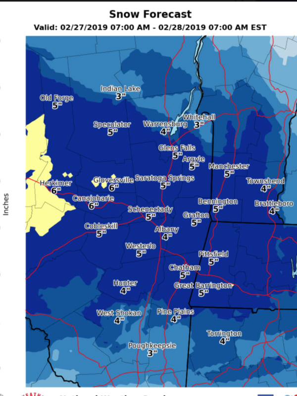
Eye On The Storm: Here's How Much Snowfall To Expect
A prolonged stretch of cold air will continue through week's end as March comes in like a lion. Those conditions will allow for two separate snow events, with the first on Wednesday, Feb. 27 into Thursday, Feb. 28. Clouds will increase Wednesday morning on a day in which the high temperature will be in the upper 20s with a wind-chill factor of between 10 and 20 degrees. Snow looks to arrive sometime between this late afternoon and early evening across the region. The steadiest snow will occur in Wednesday evening and should end by sunrise on Thursday. Most of the Dutchess area will s…
Darien
Weather
Wild Weather Week: Damaging Winds, Power Outages, Plus Some Snow
Get set for a rocky week weather-wise and a cold finish to February. It's starting off with winds of 25 to 35 mph with gusts near 65 miles per hour, leading to a High Wind Warning in effect 6 p.m. Monday, Feb. 25. (See first image above.) Hundreds of outages have already been reported throughout the region with more expected late Monday morning into the early afternoon. (Check back for separate outage updates from Daily Voice.) Monday will be partly cloudy with a high around the freezing mark and winds whipping through the region throughout the day, bringing down trees and tree limbs…
Darien
Weather
High Wind Warning: Gusts Near 60 MPH Expected To Blow Down Trees, Power Lines
This story has been updated. The heavy rain on the front end of the storm sweeping through the area will taper off early Sunday afternoon, Feb. 24. But don't let that fool you. The most damaging part of the storm will be Sunday night through late in the afternoon on Monday, Feb. 25 as strong winds will become the story. Winds of 25-35 mph may gust up to close to 60 mph. (See first image above.) A High Wind Warning will be in effect for the entire region from 10 p.m. Sunday until 6 p.m. Monday. (See second image above.) Winds of this magnitude will bring down trees, large tree limbs…
1
Archive