Find Your Daily Voice
Tags
Follow
News
Schools
Business
Obituaries
Police & Fire
Weather
Neighbors
Lifestyle
Politics
Sports
Events
Traffic
Legal
Real Estate
Tags
Jobs
Shop
Support Us
Follow
Find Your Daily Voice
News
Schools
Business
Obituaries
Police & Fire
Weather
Neighbors
Lifestyle
Politics
Sports
Events
Traffic
Legal
Real Estate
Tags
Jobs
Shop
Support Us
Home
About us
All sites
Advertise with us
Contact us
Terms of use
Privacy policy
Code of ethics
Site Map
© 2024 Cantata Media
Tag:
Wind
Arlington
Weather
Tracking Impactful Storm Blasting Region With Rain, Heavy Winds: Weather Service
Forecasters are tracking a mid-week storm set to blast the mid-Atlantic with heavy rain, wind, and in some parts, sleet. Monday, Jan. 8 will be mostly sunny with a high near 45 while Tuesday, Jan. 9 will be cloudy with a high closer to 60, according to the National Weather Service. Northern Maryland could see rain mixed with snow after 10 a.m. Tuesday. The rest of the state and the Washington DC and northern Virginia areas will see mostly rain, but there could be lots of it, the NWS said. A map released by the NWS calls for between 2.1 and 2.8 inches of rain across the DMV. A flood watch …
St. Mary's
Weather
Tropical Storm Warning Issued For Parts Of DMV Region Ahead Of Rainy Weekend
It might be a rain-soaked weekend in the DMV, forecasters are warning. A Tropical Storm Warning has been issued in parts of the region as a storm continues to develop and make its way up the East Coast. MDEM ALERT: Tropical Storm Warning for Worcester County in MD. #mdwx — Maryland Department of Emergency Management (MDEM) (@MDMEMA) September 21, 2023 The storm is expected to pick up steam in the Southeast before weakening by the time it gets to the region, though gusty winds, rain, and potential flooding are all possible. "There is the potential for life-threatening surge inundation …
Sussex
Weather
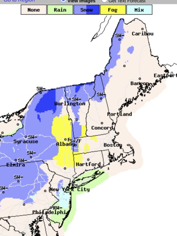
Latest Forecast Calls For Up To 18 Inches Of Snow In Parts Of NJ As Noreaster Nears
A powerful Noreaster headed to the region will slam some parts of New Jersey with up to 18 inches of snow, while the rest of the state will see rain and gusty winds, forecasters say. ALSO SEE: These NJ Schools Are Closed, Delayed Tuesday, March 14 Drizzly weather will change to snow late Monday night across Bergen, Morris, Passaic, Warren and Sussex Counties. Accuweather storm prediction.AccuWeather Sussex County is expected to get the most amount of snow: Between 12 and 18 inches, according to the NWS. Snow will change to a wintry mix around 1 p.m. on Tuesday, March 14. Precipitation …
Cape May
Weather
It's Time To 'Spring Forward,' But Storm Packed With Strong Winds Is Coming
We're just hours away from the start of Daylight saving time with clocks moving ahead one hour at 2 a.m. Sunday, March 12. Though it's "Spring Forward" time, a potent storm that will be packed with a mix of snow, sleet, rain, and strong winds that could cause power outages is headed to the region. The time frame for the storm is Monday, March 13 into Tuesday, March 14, according to the National Weather Service. A look at projected snowfall totals from the early week Nor'easter.AccuWeather.com It will be the second winter storm in the span of days as the weekend is off to a messy storm…
Burlington
Weather
Tornado Warning For Burlington, Camden, Ocean Counties
The National Weather Service issued a tornado warning for northwestern Burlington and central Camden counties until 4 p.m. A similar warning was issued for Crestwood Village and Chatsworth in Ocean County until 4:30 p.m. The storm system had weakened as it headed into New Jersey, the NWS said. A severe wind and hail warning was issued for Trenton and Hamilton Square, NJ and Levittown, PA, until 4:30 p.m. Severe thunderstorm warnings with high winds and hail were issued for Lakewood, Browns Mills and Pine Lake Park until 4:30 p.m. A tornado was possible, the NWS said.
White Plains
Weather
System Bringing Showers, Storms, Snow In Some Spots Will Be Followed By Temperature Plunge
A new storm system bringing showers and thunderstorms to the region, and some snow to areas farthest north and inland, will be followed by a big change in the weather pattern for the second half of the weekend and start of the new workweek. "While this may not be the final blast of winter-like cold for the Northeast, it will certainly pack some punch," said AccuWeather Senior Meteorologist Brett Anderson. Expect spotty showers and thunderstorms at times on Saturday, March 26, but the day will not be a complete washout at all. The high temperature will be around 50 degrees, according to the …
White Plains
Weather
Storm Will Bring Soaking Rain, Gusty Winds With Snow, Wintry Mix For Some Parts Of Region
A storm with periods of rain and gusty winds will also bring spring snowfall and a wintry mix in parts of the Northeast. The system, which has weakened after fueling tornadoes in the Southeast, arrives in this region late Wednesday afternoon, March 23. There will be rain and showers at times through early Friday morning, March 25, with the chance for snow in some areas farthest north and inland, especially overnight. Wednesday will be raw with the temperature in the mid 40s. "Wet conditions will last through Friday morning with 1 to 2 inches of rainfall expected," according to t…
Brookfield
Weather
Nor'easter Nears: Brand-New Projections For Snowfall Accumulation, Wind Speed Released
Brand-new snowfall projections have just been released by the National Weather Service for the major Nor'easter headed to the region. The time frame for the potent storm is early Friday evening, Jan. 28 into early Saturday evening, Jan. 29. "Confidence is increasing on a strong coastal storm impacting parts of Southern New England," the National Weather Service said just after sunset on Thursday, Jan. 27. "While some uncertainty remains with the exact track, we have higher confidence in significant snow/wind across eastern MA/RI with lower confidence farther inland." Besides the pote…
Darien
Weather
Here's Latest Time Frame For Storm System Bringing Heavy Rain, Gusty Winds To Region
A storm system will bring locally heavy rain and gusty winds to the region, ending a dry weather pattern in the region. The time frame for the storm is late Thursday night, Nov. 11 into early Friday afternoon, Nov. 12. The storm could cause poor drainage and urban flooding, including during the Friday morning commute, the National Weather Service said. It will be precipitation-free during the morning and afternoon on Veterans Day, Thursday, Nov. 11 with partly sunny skies and a high temperature in the upper 50s. The arrival of the storm system will bring widespread rain to the region…
Worcester
Weather
Update: Expect A Polar Vortex, Snow, And Fierce Wind Over The Next 5 Days
Break out your best Bernie Sander's style knitted-mittens and extra-thick jackets, a polar vortex is about to descend on Massachusetts and much of New England. A blast of cold wind from Canada is expected to drop temperatures to as low as 20 degrees below 0. The oncoming polar vortex may also bring snow to Central and Western Massachusetts starting on Friday, Jan. 29. In these conditions, frostbite could start to form after 30 minutes outside. The National Weather Service has issued a “hazardous weather outlook” for the region between northern Connecticut and North Worcester County. The fo…
Mount Pleasant
News
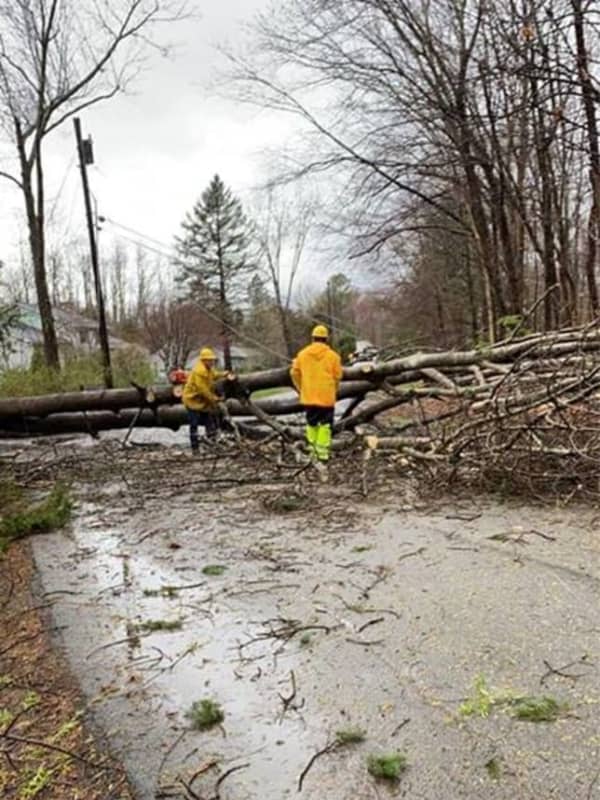
Storm Knocks Out Power To More Than 100,000 In Hudson Valley
A powerful storm system bringing heavy downpours and damaging winds has resulted in numerous downed tree limbs, leading to road closures and more than 100,000 power outages in the Hudson Valley. Here are the number of customers without power just before 8:15 a.m. on Christmas Day, Friday, Dec. 25 by utility company (click on each link for breakdowns by community): Con Edison - 17,598 NYSEG - 24,469 Central Hudson - 33,163 Orange & Rockland County - 26,107 In areas hardest hit, residents are being urged to avoid travel Christmas morning to allow utility crews to clear roadways …
Worcester
News
Forecasted Christmas Storm Intensifies, Local Travel May Be Affected
As the intensity of a Christmas storm increases, meteorologists are predicting local travel conditions may be difficult on Christmas Eve. The Thursday, Dec. 24, forecast calls for a 100 percent chance of rain in the evening and it will be heavy at times. Wind gusts are expected to reach 40 mph, according to the National Weather Service. The wet weather comes courtesy of a powerful low-pressure system and a strong cold front is expected to plow through the Central, Southern, and Eastern U.S. over the next few days - reaching Worcester County and Western Massachusetts just in time for the hol…
Nassau
Weather
Hazardous Weather Outlook Issued By National Weather Service For Powerful Christmas Eve Storm
The National Weather Service has issued a Hazardous Weather Outlook statement for a powerful system that will sweep through the area on Christmas Eve, bringing drenching rain, thunderstorms, and damaging winds that could cause power outages. The time frame for the storm is Thursday night, Dec. 24 into Friday morning, Dec. 25. "The combination of lingering snowpack and heavy rain may bring flooding, with the highest potential across northeast New Jersey, the Lower Hudson Valley, and southern Connecticut," said the National Weather Service statement, issued early Tuesday mornin…
Nassau
Weather
Storm Will Be Followed By Gusty Winds, Drop In Temperatures
A storm system that has swept through the region will be followed by clearing, gusty winds and a drop in temperatures. Some parts of the region will see as much as 2 inches of rainfall from the system, which will wrap up later in the morning on Monday, Nov. 23. Skies will gradually clear after noontime just as strong winds move in. The temperature will fall in the afternoon from the mid 50s to the mid 40s on a breezy day with wind strength of 10 to 15 miles per hour and gusts up to 25 mph. As a result, it will feel more like it's in the 30s by the time nightfall arrives. The overni…
Nassau
Weather
Sunny Last Day Of Summer Will Be Followed By Scattered Storms, Big Change In Weather Pattern
The summer of 2019 will be one for the books in just a matter of hours, and then a big change in the weather pattern will come, along with the end of a long stretch of dry days. So it's fitting that Sunday, Sept. 22, the last day of summer, will be, well, summer-like with the high temperature well above normal. It will be warm, with temperatures climbing into the low to mid 80s with plenty of sunshine and higher humidity. It could be the warmest last day of summer since 1980, in fact. The first day of fall, Monday, Sept. 23, could be even warmer with a high temperature in the mid 80s under…
Nassau
Weather
Snow Way! Parts Of New York Will See White Stuff Just Days From Start Of May
Are you sitting? OK. Here goes. Just days away from the start of May, some residents in the region, including a large part of New York State, may be seeing some snow this weekend. (See image above.) Snow showers could bring a coating of accumulation as far south as the northwestern Hudson Valley, including Sullivan County. The white stuff is expected early Sunday morning, April 28 as a round of precipitation moves west to east. It's the same storm that is bringing up to 6 inches of snowfall to some states in the northern Plains and Great Lakes regions early in the weekend. In this …
Darien
Weather
Flash Flood Watch: Significant Storm System Will Bring Downpours, Delay Holiday Travel
A significant storm system in the pre-Christmas travel days at the end of the week is headed our way. Heavy rain, wind, and coastal flooding are all likely. A Flash Flood Watch is now in effect from 1 a.m. Friday, Dec. 21 until 1 a.m. Saturday, Dec. 22. The National Weather Service is now forecasting 1.5 to 2.5 inches of rain with locally higher amounts, especially in any thunderstorms, with most of the area in a marginal risk for excessive rainfall. It looks to be too warm for any snow across the region. The forecast will be fine-tuned with amounts and when to expect the heaviest r…
New Canaan
Weather
New Round Of Soaking Rain, Gusty Winds, Storms Coming Our Way, Including On Election Day
Sunday's sparkling skies and pleasant conditions will prove to be the calm before a new round of storms with soaking rain and gusty winds at the beginning of the workweek. The stormy stretch comes after a storm system swept through the area, bringing heavy downpours overnight Friday into Saturday, followed by high winds that caused thousands of power outages. After clouds increase overnight Sunday into Monday, rain will arrive after 9 a.m. Monday and continue through late in the evening on a day in which the high temperature will be in the low-50s. Up to a half-inch of rain is pos…
Stamford
News
Move Your Car: Stamford Prepares For Snowstorm
STAMFORD, Conn. – Mayor David Martin is reminding residents that impending snow, extreme cold, and windy conditions are in the forecast for Stamford for Thursday. A Winter Storm Warning is in effect for the Stamford area, with snow, wind and coastal flooding in the forecast for Thursday with possible accumulations of 3 to 7 inches possible. The snow is expected to begin late Wednesday night. Bitter to dangerous cold, with wind chills -15 to -25 are predicted with wind gusts from 15 to 40 mph to begin late Thursday and continue into late Friday. Bitter cold is expected to follow the storm…
Armonk
Weather
Nor'easter Approaching Area Reaches 'Bomb Cyclone' Status
While the East Coast gears up for the rapidly approaching Nor'easter that’s expected to pummel the area overnight, locals can also expect to experience another weather phenomenon known as a “bomb cyclone.” The National Weather Service has predicted that the region may see anywhere from 2 to 4 inches of snow, with the storm expected to hit the area beginning around 1 a.m. on Thursday morning. According to the National Ocean and Atmospheric Administration, “bombogenesis, a popular term used by meteorologists, occurs when a mid-latitude cyclone rapidly intensifies, dropping at least 24 milliba…