Find Your Daily Voice
Tags
Follow
News
Schools
Business
Obituaries
Police & Fire
Weather
Neighbors
Lifestyle
Politics
Sports
Events
Traffic
Legal
Real Estate
Tags
Jobs
Shop
Support Us
Follow
Find Your Daily Voice
News
Schools
Business
Obituaries
Police & Fire
Weather
Neighbors
Lifestyle
Politics
Sports
Events
Traffic
Legal
Real Estate
Tags
Jobs
Shop
Support Us
Home
About us
All sites
Advertise with us
Contact us
Terms of use
Privacy policy
Code of ethics
Site Map
© 2024 Cantata Media
Tag:
Snow
Union
Weather
Snow Showers Could End Storm Bringing 2 Inches Of Rain To NJ, PA: NWS
A weekend of rain could end in snow in parts of New Jersey and Pennsylvania, according to the National Weather Service. A flood watch for much the region from 1 p.m. Saturday through through Sunday evening as a low-pressure storm is set to bring up to drop two inches of rainfall, according to the NWS. Paired with the multiple rounds of rainfall from the past several days, this new round "is likely to bring several river gauges into flood stage across the Passaic, Raritan, and Rancocas basins by Sunday," the NWS said. By Sunday is expected to be partly sunny with scatte…
Arlington
Weather
Drenching Rain, 45 MPH Winds: New Storm Moving Toward Northeast
Forecasters are warning of a weekend storm bringing widespread rain and gusty winds to the Northeast, creating yet another flood risk. Thursday, March 7 will be be mild with scattered showers while Friday, March 8 will be mostly sunny with temps in the mid-50s, forecasters say. Saturday, March 9 is when the new storm will begin moving into the region with rain beginning in the afternoon and lasting overnight, according to the National Weather Service. About an inch of rain is expected to fall, which the National Weather Service says isn't much, but given an already-wet ground "there is pot…
Arlington
Weather
Change In Weather Pattern Bringing Rain, Warmer Temps To Region: Forecasters
A change in the weather is bringing warmer weather and rain to the mid-Atlantic and Northeast, closing out a dry week with mild temps, forecasters are saying. Wednesday, Feb. 21 will be mostly sunny with a high near 45, melting snow that fell last week, the National Weather Service says. The snow could re-freeze as temps dip just under 30 at night, but a warm-up Thursday means the precipitation eyeing the region likely won't be more snow. Good morning! Expect a slightly warmer day today compared to yesterday with mostly sunny skies. The forecast hasn't... Posted by US National We…
St. Mary's
Weather
Snow Likely In Most Of Maryland, Virginia Heading Into Holiday Weekend: Forecasters
A new round of snow could be coming to parts of the DMV region as soon as Friday night or Saturday morning, according to forecasters. A new fast-moving storm could bring upwards of three inches of snow to some areas, AccuWeather officials said, with a wintry mix possible as far south as Richmond, though it is expected to pass quickly. Mild temperatures are expected today with increasing clouds ahead of a weather system to our north. Some rain showers will reach the Allegheny Mountains later this afternoon. pic.twitter.com/97ro1l3Y3w — NWS Baltimore-Washington (@NWS_BaltWash) February 15,…
Howard
Weather
Rain May Turn To Snow In Parts Of DMV Region During Shifty Incoming Storm: Forecasters
Some parts of the DMV region could be hit with snow as another round of storms is expected to roll through the area. Forecasters are advising that some parts of the area could see winter weather, specifically in the mountains, though many other neighborhoods will only see rain falling beginning late on Monday and into Tuesday morning. We have some winter weather on the way for Maryland including potential snow fall tonight into tomorrow. Keep an eye on @NWS_BaltWash, your local forecasts, and here for continued updates. #MdWx https://t.co/3jWmTmz5Uo — Maryland Department of Emergen…
Sussex
Weather
Chance Of Snow For NJ, PA In Sunday Soaker: Forecasters
Temperatures are expected to surge near 60 by the end of the week, but come next, parts of New Jersey and Pennsylvania could be back in old man winter's grip, forecasters say. According to AccuWeather, a storm on Sunday, Jan. 29 will bring rain to major cities. For northwest New Jersey, northern Pennsylvania and parts of Central Pennsylvania, however, a mix of rain and snow — or perhaps just snow — is expected. Thursday, Jan. 25 will be rainy and foggy with a high near 50 while Friday, Jan. 26 will be the same but slightly cooler, the NWS said. Saturday will be partly sunny with a hi…
Union
Weather
Threat Of Freezing Rain Prompts Winter Weather Advisory Across Parts Of NJ, PA
The threat of freezing rain and icy roads has prompted the National Weather Service to issue a Winter Weather Advisory across portions of North Jersey and the Lehigh Valley. Bergen, Sussex, Warren, Morris, and Passaic Counties, along with the Poconos Mountains and the Lehigh Valley are expected to see freezing rain and snow Tuesday night, Jan. 23, the NWS said. The areas in the purple on the NWS map below are under a winter weather advisory. While Old Man Winter has likely released his grip on most of the region through the rest of the week, light icing is expected near the I-80 corrid…
Washington
Weather
More Snow: New Projections Released For Storm Headed To MD, VA
The National Weather Service has released a brand-new map showing projected snow totals coming to the mid-Atlantic later this week. Wednesday, Jan. 17 is expected to be "very cold" with temps struggling to reach the freezing mark southeast of Washington DC in the afternoon, the NWS said. Sunny skies are expected today, but it will remain very cold. Posted by US National Weather Service Baltimore/Washington on Wednesday, January 17, 2024 Thursday, Jan. 18 will be another dry day but with increasing clouds, and not quite as cold. A cold front will come in on Thursday night into…
Stafford
Schools
Snow Day! Weather Closes Schools Across Virginia
Schools across Northern Virginia are closed Tuesday, Jan. 16 due to the snow. Snow began falling across the region Monday, Jan. 15, and is expected to turn to a wintry mix overnight. All Fairfax, Stafford, Loudoun, Prince William, Alexandria, and Arlington public schools will be closed on Tuesday. The National Weather Service shows Northern Virginia is expected to see 1 to 3 inches by the end of the night Monday, Jan. 15. Rain, snow, and freezing rain will fall likely before noon, with another chance of snow later in the day, making for hazardous road conditions.
Warren Hunterdon
Weather
Tracking Weekend Snow, Mid-Week Rain Storms Both Heading Toward Northeast
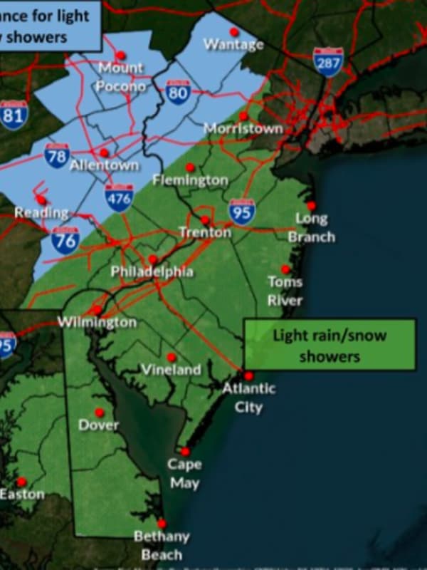
Parts of the region will be shoveling out of several inches of snow from the weekend when another strong storm system moves in, forecasters are saying. On Friday, Jan. 5, the National Weather Service released a new model showing between eight and 12 inches of snow in Sussex and Warren counties in New Jersey, and the Pocono mountains in PA (scroll for map). The chance of snow isn't looking good for greater Philadelphia this weekend, the NWS says, noting snow-lovers in the area will be "disappointed" by this weekend's system. "Our latest forecast has only a 3% chance of seeing 1" or more of …
Union
Weather
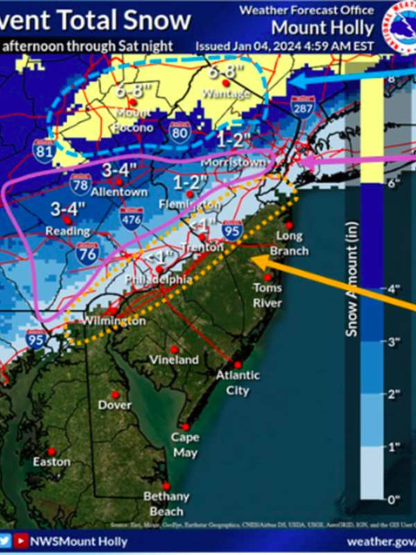
New Forecast Map: 7 Inches Of Snow Could Fall In Parts Of NJ This Weekend
Some parts of New Jersey and the Lehigh Valley/Pocono mountains could get up to seven inches of snow this weekend, according to newly-released forecast maps. The National Weather Service's Mount Holly office released a new forecast map on Thursday, Jan. 4 — two days before heavy snow is expected to make its debut after nearly two years in the Northeast. ⚠️❄️ A coastal system will bring widespread precipitation to our region. Snow and some mixed precip will occur northwest... Posted by US National Weather Service Philadelphia/Mount Holly on Thursday, January 4, 2024 ⚠️ A lot of …
Arlington
Weather
Wintry Mix Of Rain, Possible Snow Expected In DMV Region Over Weekend
Forecasters are expecting a wet, wintry weekend throughout the region as storms make their way toward the DMV region. During the first weekend of 2024, there will be "an enhanced winter storm threat" for portions of region beginning on Saturday and extending through the evening, according to the National Weather Service There is an enhanced winter storm threat for portions of our region Saturday into Saturday night. The highest confidence for impacts of snow & ice appear to be along & west of the Blue Ridge. This forecast will continue to change. Latest at : https://t.co/ZOlvEShg…
Arlington
Weather
Thunderstorms, Possible Snow Heading Toward DMV
Meteorologists are cautioning that some wicked weather may be barreling towards Maryland and Virginia. While temperatures were on the rise over the weekend, the fun may be over as forecasters are calling for thunderstorms, and possibly even some snow to parts of the region. According to the National Weather Service, snow is most likely in the western parts of Maryland and Virginia, with accumulations of less than one inch expected in the majority of the area, though some extreme forecasts have called for upwards of four inches in more rural areas. Flood Watches have been expanded …
Dauphin
Weather
Snow Coming To PA In Powerful Weekend Storm (
Timing
,
Updates
)
Several inches of snow could fall across parts of Pennsylvania in a powerful storm headed to the region this weekend. While the weekend will begin with a warmup with temps expected to reach 59 come Sunday, Dec. 10, a cold front isn't far behind. By Sunday night, temps will hit a low of 33. Rain and thunderstorms that will have begun in the morning will turn to snow in the northernmost swath of Pennsylvania and greater Pittsburgh (see weather map above). "One zone that has a higher chance of picking up 6 inches of snow during Sunday night is from north and east of Scranton, Pennsylvania to …
Hackensack
Weather
Snow Flurries Fall Across North Jersey: What To Expect, Timing
Parts of New Jersey and Pennsylvania were expected to see a dusting of snow Wednesday, Dec. 6. The National Weather Service was showing wintry weather in northwest New Jersey, the Lehigh Valley, and the Poconos, with flurries already falling as of 2 p.m. We can expect to see some light snow showers and flurries throughout the day Wednesday, with the greatest chance across... Posted by US National Weather Service Philadelphia/Mount Holly on Wednesday, December 6, 2023 Parts of Bergen and Passaic counties were also expected to get light snow Wednesday afternoon, and Thursday afternoo…
Arlington
Weather
Snow Could Fall This Week In Northern Virginia: Here's The Timing
A rainstorm expected Tuesday evening, Dec. 5 could turn to snow by morning, according to the National Weather Service. Tuesday will be mostly cloudy with a high near 50 with rain expected after 8 p.m. A slight chance of rain and show is forecast for Wednesday morning, Dec. 6 before 7 a.m., then a slight chance of snow showers by 10 a.m. Temps will remain in the mid-40s as precipitation clears. Temps will gradually raise to between 45 and 55, to close out the week, according to the NWS.
Washington
Weather
Wintry Mix To Become All Snow In Parts Of PA, MD: Here's The Timing
Wintry weather will become snow in parts of Pennsylvania and northern Maryland Tuesday, Dec. 5, the National Weather Service says. The Alberta Clipper formed in the Midwest on Monday, Dec. 4, and will exit over the mid-Atlantic on Tuesday night, Dec. 5, AccuWeather reports. According to the NWS' Pittsburgh station, a wintry mix is expected sometime later this morning and through the afternoon, before all precipitation turns to snow. The most likely areas for the mix would be south of I-80, while further south, say south of I-70, the precipitation may change to all rain for a time this afte…
Union
Weather
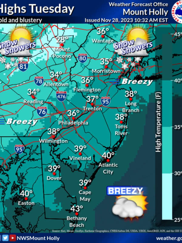
Snow Flurries Possible This Evening In Parts Of North Jersey
Wintry weather may be working its way through parts of North Jersey later today, Tuesday, Nov. 28. The National Weather Service was predicting up to a 40 percent chance of flurries in the northern and westernmost parts of the state in the late afternoon and evening hours. Bergen, Passaic, Essex, Morris, Union, Sussex, Warren, and Hunterdon counties could all see snow through the evening, according to the NWS. The greatest chance of snow is in Sussex County, where the NWS predicted a 40% chance of flurries before 5 p.m. 🥶🧥 Temperatures will remain steady in the 30s for the remainder o…
Warren Hunterdon
Weather
Chance Of Snow Predicted In Parts Of NJ As Temps Drop
A slight chance of snow showers are possible in parts of North Jersey this week as temperatures plummet. Monday, Nov. 27 will be sunny with a high of 44 but temperatures are expected to drop to the mid-20s in the evening, the National Weather Service says. A slight chance of snow is being predicted in Sussex County Monday night, the NWS says. Good morning! Here is your forecast for the start of the new week. It will be mild today with some passing clouds, but... Posted by US National Weather Service Philadelphia/Mount Holly on Monday, November 27, 2023 Tuesday, Nov. 28 will be mostly s…
Alexandria
Weather
'Get Ready For A Winter Wonderland': Old Farmer's Almanac Releases 2023-24 Forecast
The mild winter of 2022-23 may become a distant memory with more typical conditions expected in 2023-24, according to the Old Farmer's Almanac. "The 2024 Old Farmer’s Almanac predicts snow, seasonable cold, and all of winter’s delights," states the publication, which has been making long-term weather forecasts since 1792. "This winter’s forecast is sure to excite snow bunnies and sweater lovers alike, promising a whole lot of cold and snow across North America." In the Northeast, snow will arrive beginning in November, with storms, showers, and flurries continuing through …
New Haven
Weather
'Get Ready For A Winter Wonderland': Old Farmer's Almanac Releases 2023-24 Forecast
The mild winter of 2022-23 may become a distant memory with more typical conditions expected in 2023-24, according to the Old Farmer's Almanac. "The 2024 Old Farmer’s Almanac predicts snow, seasonable cold, and all of winter’s delights," states the publication, which has been making long-term weather forecasts since 1792. "This winter’s forecast is sure to excite snow bunnies and sweater lovers alike, promising a whole lot of cold and snow across North America." In the Northeast, snow will arrive beginning in November, with storms, showers, and flurries continuing through the sta…
Nassau
Weather
Storm Watch: Here's Timing For New Round Of Rainfall, With Snow Possible In Spots
An approaching storm system will bring a new round of precipitation throughout the region. After a sunny start, clouds will increase on Monday, March 27 with a chance for rain starting in the middle of the afternoon as a low-pressure system passes to the south, according to the National Weather Service. It will be cooler with the high temperature in the low 50s. Rain is expected during the evening Monday and into the early overnight hours, with a mix of rain and snow showers inland, and light snow possible in areas farther north. Little or no snow accumulation is expected. …
Nassau
Weather
Dry Wrap-Up To Weekend Will Be Followed By New Round Of Rainfall, With Snow Possible In Spots
A raw, wet start to the weekend will be followed by a dry day with plenty of sunshine on Sunday, March 26 before a new round of precipitation sweeps through the region. The high temperature on Sunday will range from the upper 50s to around 60 degrees, according to the National Weather Service. It will remain breezy with occasional 25-mile-per-hour gusts before winds subside in the evening. Clouds will increase on Monday, March 27 with a chance for rain starting after around noontime. It will be cooler with the high temperature hovering around the 50-degree mark. Rain is expected over…
Norwalk
News
Nor'easter: Storm Knocks Out Power To Thousands In CT, With These Communities Most Affected
A late-winter Nor'easter has already left thousands of Connecticut residents without power as it batters the state with snow, rain, and strong wind gusts. Related Story - Nor'easter: Potent Storm With Gusty Winds Brings Mix Of Snow, Rain, Causes School Closures The storm arrived on Monday evening, March 13, and has continued into Tuesday, March 14, bringing steady rain and even snowfall in the areas of the state north of the I-84 corridor. Along with precipitation, the Nor'easter has also brought strong wind gusts as high as 40 to 50 miles per hour to the state, knocking d…
Sussex
Schools
These NJ Schools Are Closed, Delayed Tuesday, March 14
Parts of New Jersey could get slammed with up to 18 inches of snow in the first Nor'easter of the season, making for messy commutes, the National Weather Service said. The rest of the state will see only a few inches of snow, rain or a wintry mix, according to the NWS. Here are the schools that have announced closures or delays for Tuesday, March 13 (be sure to check your school's website for specifics): Delayed: Bloomingdale Chester Dover Jefferson Township Kinnelon Lenape Valley Regional High School Manchester Regional Mendham Mount Arlington Mount Olive Morris Hills Morris Knolls Morr…
Sussex
Weather
Latest Forecast Calls For Up To 18 Inches Of Snow In Parts Of NJ As Noreaster Nears
A powerful Noreaster headed to the region will slam some parts of New Jersey with up to 18 inches of snow, while the rest of the state will see rain and gusty winds, forecasters say. ALSO SEE: These NJ Schools Are Closed, Delayed Tuesday, March 14 Drizzly weather will change to snow late Monday night across Bergen, Morris, Passaic, Warren and Sussex Counties. Accuweather storm prediction.AccuWeather Sussex County is expected to get the most amount of snow: Between 12 and 18 inches, according to the NWS. Snow will change to a wintry mix around 1 p.m. on Tuesday, March 14. Precipitation …
Cape May
Weather
It's Time To 'Spring Forward,' But Storm Packed With Strong Winds Is Coming
We're just hours away from the start of Daylight saving time with clocks moving ahead one hour at 2 a.m. Sunday, March 12. Though it's "Spring Forward" time, a potent storm that will be packed with a mix of snow, sleet, rain, and strong winds that could cause power outages is headed to the region. The time frame for the storm is Monday, March 13 into Tuesday, March 14, according to the National Weather Service. A look at projected snowfall totals from the early week Nor'easter.AccuWeather.com It will be the second winter storm in the span of days as the weekend is off to a messy storm…
Nassau
Weather
These Areas Could See Snowfall From Potent Storm Headed To Northeast
A complex new storm on track for the Northeast is expected to bring a mix of rain, sleet, and snow. Ahead of the arrival of the system, there will be a return to warmer-than-normal temperatures for this time of year Sunday, Feb. 19, and Presidents Day on Monday, Feb. 20 into Tuesday, Feb. 21, according to the National Weather Service. High temperatures during that street will range from the upper 40s to low 50s with cloudy skies each day, Showers are possible both Monday and Tuesday, with some areas seeing snow showers overnight Monday into Tuesday morning. The potent stor…
New Haven
Weather
Fast-Moving Storm Will Bring Mix Of Rain, Sleet, Snow: Here's What's Coming
Click here for a new, updated story: Midweek Storm Will Be Second To Sweep Though Region This Week: Here's Latest On Both A fast-moving storm will bring a mix of rain, sleet, and as much as a foot of snow to parts of upstate New York and areas in New England. The system is on track for Sunday afternoon, Jan. 22 into Monday morning, Jan. 23. Accumulating snowfall will be in interior portions of the Northeast. Most of the region will see rainfall from the storm (shown in green in the first image above from AccuWeather.com), with up to about 1 inch possible. Projections …
Hartford
Weather
Timing Shifts For Cross-Country Winter Storm On Track For Northeast
A quick-moving system brought light snow to parts of the region, leading to slippery conditions in spots just before daybreak on Monday, Jan. 9. With a stretch of dry days upcoming, attention is now turning to a coast-to-coast system that is now due to arrive in the Northeast earlier than originally expected, on Thursday, Jan. 12. (See the first image above from AccuWeather.com.) Mainly rain (shown in green) is expected in much of the region Thursday into Friday, Jan. 13 with a wintry mix possible farther inland (pink) and snow in some parts of northern New York and…
Morris
Weather
Two Inches Of Snow Possible 'If Everything Lines Up Just Right' In Northeast
If everything lines up just right this weekend, parts of the Northeast could get up to two inches of snow, the National Weather Service says. More likely than not, though, those areas will see just a light coating, "if that," the NWS said. Good morning! If you're hoping for snow, this is the best we can do for now. A weak system will pass to our south Sunday... Posted by US National Weather Service Philadelphia/Mount Holly on Friday, January 6, 2023 Temps on Saturday, Jan. 7 will be in the mid-40s with a low of 29, and on Sunday, the high will be 42 with a low of 32. A map from AccuWe…
1
2
3
4
5
6
7
8
9
10
Archive